Gotta' Have Maps...

-K2-

Well-Known Member
Joined
Jun 19, 2018
Messages
2,100
Just for fun and to give my mind something to do away from writing while staying connected to the project, in my recent work I've been making maps. Now, these are all roughs as I hash out ideas for final versions. The first image is from a new distant future project I'm hashing out, and the last set is the extent I've detailed out the mapping to my series, the first two novels moving into a beta stage.

From "***Not Telling***"; rough version before converting to monochrome:
(BTW, those sub-lines and dots around the compass rose ring mark precisely (used an overlaid protractor) the angle of the sun at each solstice and equinox for the location in the center of the map, and projected declination deviations travelling from one 'shield' to the other.)

standalone


To show the precision of what I generated, this shows scale USGS under-laid in AutoCAD that I then alter in Photoshop which helps me get the non-gps grid system set up:

52090


That then allows me to generate other story supporting maps like the planned and ultimate Case City area:
52091


Then I add in projected 'sea rise' using precise topographical maps (this an old rough for South Philadelphia):
52092


And ultimately I work down to specific areas the story takes place (another old version). That way, as the characters move around I can describe accurately how the post-apocalyptic city would actually look (IOW, you could read the story, follow the route and connect the dots using satellite imagery):
52093


K2
 
Last edited by a moderator:
In Judge Dredd isn't there supposed to be only one big refuge City in the US? From Boston to Washington DC.
 
You've really put some work into these maps, K2. Nicely done sir. My maps are ah, not at your level and only used as reference points for my stories.
 
In Judge Dredd isn't there supposed to be only one big refuge City in the US? From Boston to Washington DC.

Actually, if you look at their drawn map, it looks like this:
52567
52610


Mega-City 1 is the large orange area:
377,000 sq.mi. / 100-million pop. / 265 per sq.mi. density

The dark area inset, Consolidated America Sanctuary East, Case City stands at:
5,400 sq. mi. / 417-million pop. (458-m. initially) / 77,222 per sq. mi. density (64% of the pop. at 232,000 to 833,000/sq.mi.)

You've really put some work into these maps, K2. Nicely done sir. My maps are ah, not at your level and only used as reference points for my stories.

Thanks @Droflet ; that's very kind of you, but those above are very old, very rough maps. What I'm showing below are even obsolete now (I wanted better quality):

CASE-G2-Bsm2.jpg


test3a.jpg
----
sample.jpg


test4.jpg


All of CASE is mapped out--to scale--using its own grid reference system (which there is a point to), in other words, 5,400 sq. miles in CAD...down to 125m grids.

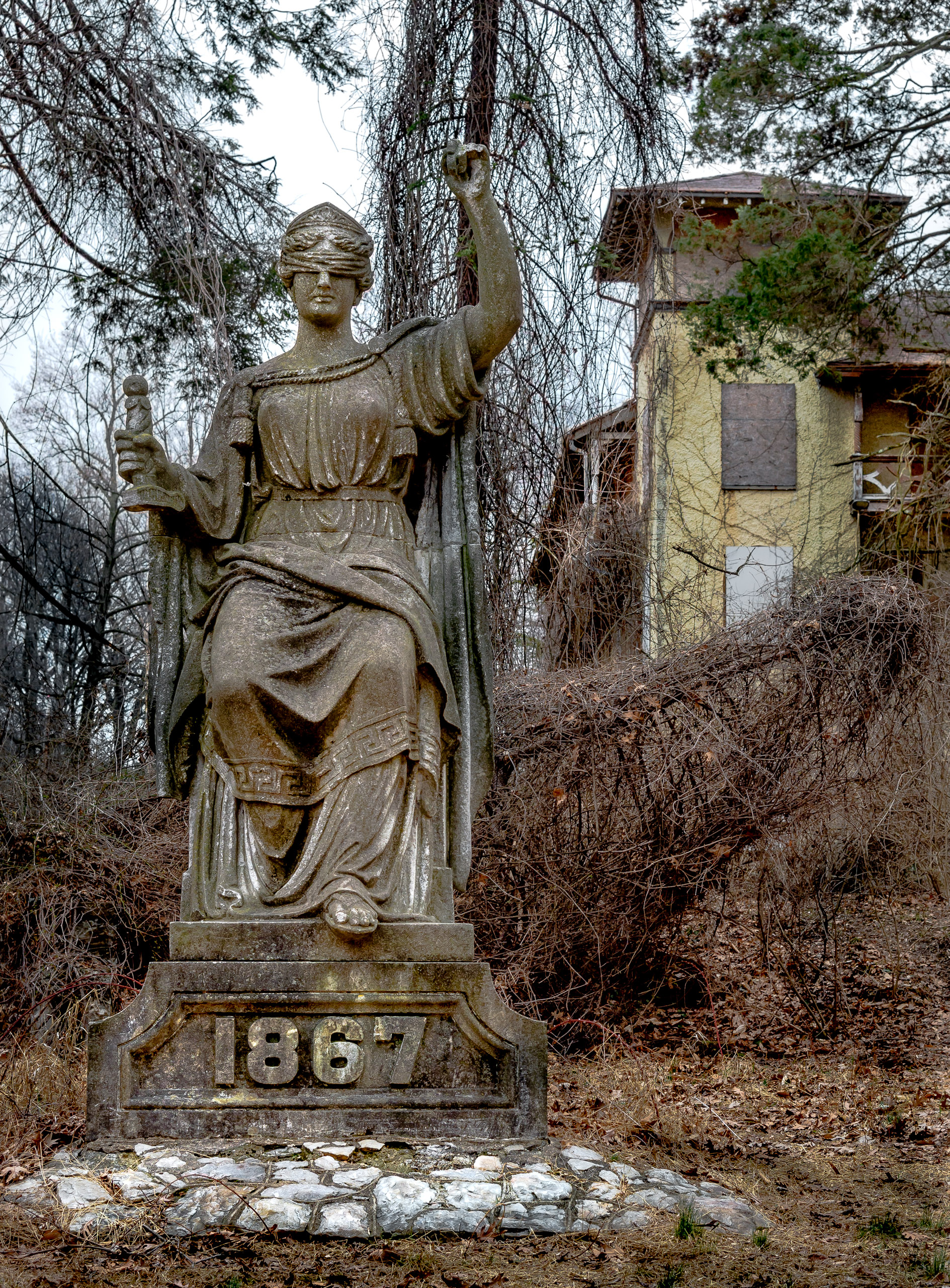
In any case *snort*, I've had to work out realistic sea rise for the region, geologic issues (since it will cause buildings to collapse), a whole bunch of stuff. I even discovered an old statue of Justice that is now in an obscure defunct girls school in Wash.DC, but used to be on a bank in NYC, moved there by women in the suffrage movement which promotes the -every person is a patriot- theme, and establishes the CASE grid system center line.

(King1893NYC)_pg739_THE_NATIONAL_PARK_BANK_OF_NEW_YORK._214_BROADWAY,_BETWEEN_FULTON_AND_ANN_S...jpg
63182469_1468641651.jpg
gallery-6164.jpg


Point to the detail is so folks could actually follow precise routes and places in the story. Though I get somewhat vague as to exact buildings in the story (I don't want to get sued, hehe), I've used exact details (floor plans) of specific buildings the characters move through...so, you could personally stand in the exact place a story event happens.

Fun :giggle:

K2
 
Last edited:
Wow, love the maps, puts mine to shame
This is the map I use for my Feral / Stagger Lee storyline.

Well, it's not a matter of one being better or worse than another. It's what suits and works to accomplish what you're wanting for your story.

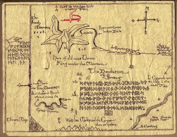
E.g.: I 'believe' this is one of Tolkien's maps for the Hobbit (others can confirm that):
Bsbv3S-IUAAGK5A.jpg


Who's going to say, "X, Y, or Z is a better map," considering its success?

My maps and system I've vaguely mentioned are detailed as they are for numerous reasons. How valid those reasons are is another question. In any case, the above maps are specific because my story takes place in a very near future scenario. So near, if any of it was wrong and someone wanted to press it, it could be argued that considering how specific I was, I'm somewhat obligated to get it right ;) IOW, it's a real place that exists today...that will tomorrow and in my story, so...

In something else I'm poking at, it has two maps which I need to make even more primitive than they are:

R1.jpg


R2.jpg


That's an entire massive continent you might recognize. But, it is more than enough for the story, and even then except for wanting the impact that only comparative images can give, it's likely not needed.

One stories needs are not the same as another and many might justifiably argue, perhaps aren't needed at all ;)

K2
 
Very nice maps, both of you!

@JJewel I don't think your map looks bad at all! Some times a more hand-drawn affect to a map suits a story better depending on the books storyline. I've seen some maps that, while amazing detailed and precise, they didn't have as much impact visually to me as other, less 'perfect' maps because they just looked like they came out of an atlas. I just felt cold and disconnected by them rather than excited that there was a map and wanting to dive into it.

E.g.: I 'believe' this is one of Tolkien's maps for the Hobbit (others can confirm that):

Yup, it is. I've always loved that map.

I don't have any maps in my books yet, but I do plan to do so eventually. Sadly, some books benefit from maps more than others and most of mine haven't done so so far, or at least my first one didn't. My second one has more possibility for adding maps to it, but I have to finish it first. I love maps though so I do want to make some at some point.
 
Some of my old maps (of different types, and of places on different worlds) with some of the names/labels screwed up by changing the file type**:

1726931009431.png


1726931649217.jpeg


1726931248586.jpeg


** - The original files of all three were created in PowerPoint... although there was an earlier hand-drawn map of Hydropolis (the country), of which the one shown above was a much-mis-remembered version (the hand-drawn one having gone AWOL for quite a long time).
 

Similar threads


Back
Top