Maps

Someone is mapping all the trees in London: TreeTalk

If you want to know what tree it is, hover over the location! Click for more info. Unfortunately, the trees where my story I'm working on is set aren't mapped. I think I identified the right trees from photos. But I also think I didn't. I called the trees on Constitution Hill lime trees, when I think they may be London plane (a species I didn't know of until the map).
 
FAAE6706-B6FD-45B2-80FA-CD1233214497.jpeg
 
Is it true that the Ordnance Survey has stopped making paper maps -- it's all digital now?
 
Right, Harpo, but check this....

That article is from seven years ago, and sales of paper OS maps increased in recent years. There are also competitors like Harvey Maps, so the market must be there.

I visited Cornwall last year and rather than buy a paper map for everywhere I was going, I bought paper maps for the locations I needed them most and bought a digital subscription via the ViewRanger app that covered the UK. Downloading maps was very fiddly and time-consuming, and then when it came to using the maps, there were so many issues, it's a good job I didn't need to rely on them. I was looking forward to having the whole of the UK's OS mapping available, but I cancelled my subscription to ViewRanger immediately.

I got a shock in Bulgaria when walking up a mountain in snow, and now I know most maps for sale outside the UK are nowhere near as detailed as those available in the UK - we're so lucky here! In Bulgaria, what looked quite a straightforward route was actually very winding, and of course the snow made routes more difficult to follow.

This is maybe a quarter of my maps - some of the best money I've ever spent!

os-maps.jpg
 
I remember a glimpse of an old atlas my mother had when she was young, which was already several decades out of date when she got it. In addition to the general humongousness of the British, Ottoman and Austro-Hungarian empires, I was struck by the maps detailing the Silk Roads across Asia and the main trans-Saharan caravan routes.

...
I got a shock in Bulgaria when walking up a mountain in snow, and now I know most maps for sale outside the UK are nowhere near as detailed as those available in the UK - we're so lucky here! In Bulgaria, what looked quite a straightforward route was actually very winding, and of course the snow made routes more difficult to follow.
...

The French survey maps I've seen are impressively detailed, on a par with Ordnance Survey. Which makes sense- my understanding is that there was a literal cartographic arms race between Britain and France, each driven by fear of invasion by the other. At the other end of the scale, I have a map of Mumbai where the streets included are more up-to-date than the coastline of the reclaimed land. Several neighbourhoods are depicted as lying in Thane Creek or the Arabian Sea.
 
>The French survey maps I've seen are impressively detailed
This goes back at least to Napoleon, who sent out teams all across France to draw up detailed maps for military purposes. There's a nice anecdote told by Eugen Weber (in Peasants into Frenchmen) about how one team was on a rise outside a village, drawing their map. They were set upon by the villagers, who were convinced that those strangers on the hill could only be casting some sort of evil spell what with their books and scrolls and strange instruments.
Saw an old advert for the Irish Ordnance Survey that read something like 'applicants must be able to endure harsh lodgings and be prepared to wrestle with several rude individuals' ...must've gone with the territory (scuse the pun) back in the day!
 
I think it did. I worked one summer for the Utah State Historical Society. We were mapping historical buildings or, rather, candidates for historical status. As part of that, we student workers were each given a camera. I bicycled around downtown Salt Lake City, the periphery of same, where there were still homes. I had more than one person come out and demand what the hell was I doing. Most said oh, but a couple shooed me off. Sort of an invasion of privacy, I guess. Or generalized suspicion of outsiders. So the story about the French map makers rings true.
 
A friend of mine was surveying a bit of road recently when someone came out of one of the houses next to it. A well spoken middle aged fella who explained that surveying was a waste of time because it is based on a false assumption of the Earth being a sphere. He went off, came back with a laptop, and insisted on playing several videos that proved the Earth was flat -takes all sorts;)
 
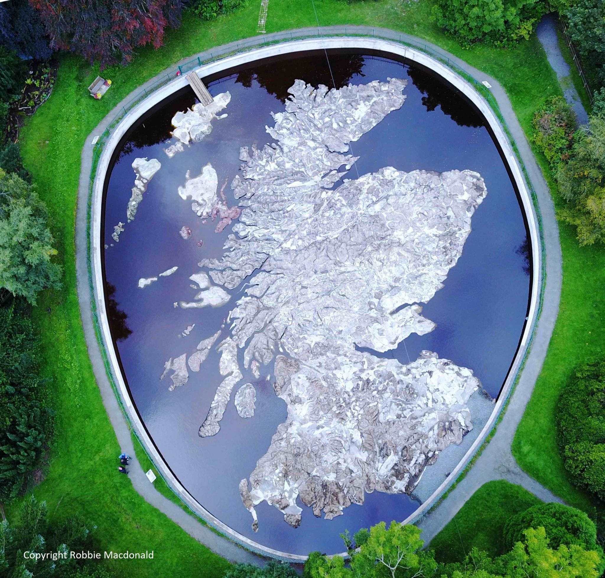
A recent letter in a local newspaper from an old boss of mine (retired for many years now) reminded me that when he retired, he had been involved in restoring a very unusual map. It’s a 50 by 40 metre map of Scotland in stone. Here’s a site with all the details.
 
A recent letter in a local newspaper from an old boss of mine (retired for many years now) reminded me that when he retired, he had been involved in restoring a very unusual map. It’s a 50 by 40 metre map of Scotland in stone. Here’s a site with all the details.
Yep, it looks amazing. My house is literally under the entrance ramp.
Edit: ok not *literally* but you know what I mean.

D8929398-7771-4EFB-AB8E-05AB4F019A32.jpeg
 
It’s a 50 by 40 metre map of Scotland
By the looks of it, they should have either used a larger site, or reduced the scale, as they seem to have missed one or two of the islands to the west and, in particular, the north.
 

Similar threads


Back
Top